Mapas historicos de Nuevo Mexico = Historic New Mexico Maps
Funded
Summary
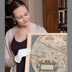
The Mapas historicos de Nuevo Mexico = Historic New Mexico Maps cataloging project made one of the most important collections of the Fray Angelico Chavez History Library accessible to a wide range of researchers, historians, students and the general public. The History Library is the institutional successor of New Mexico's oldest library (1851) and is part of the New Mexico History Museum/Palace of the Governors. A non-circulating, closed stack research facility, it preserves historical materials -- manuscripts, maps, rare books -- documenting the history of the state, and the American Southwest from pre-European contact to the present. The map collection of primary historical documents is a major source of information about perspectives, beliefs and attitudes of the past. The collection offers both scholars and history buffs the opportunity to see the American Southwest from the viewpoint of early Spanish explorers and the topographers of the Army of the West. Over 5,500 maps ranging from blueprint railway maps, surveyors maps for Western expansion, and 18th century manuscript maps of Bernando de Miera y Pacheo, which all showcase the long and varied history of the region, are held in one repository, making a wide range of research possibilities available for scholarship. The proposed cataloging project will make this unique historic map collection more widely known and enable us to assist researchers more efficiently.
Program
Amount Requested
$179,600
Year Added
Institution
History Library
Contact(s)
- Patricia Hewitt
Collection Size
5500 objects
Date Range
1550 - 2000
Geographic Scope
Southwestern United States; New Mexico; Santa Fe; Mexico; Colony of New Spain; Western Hemisphere; Miscellaneous maps of many US states